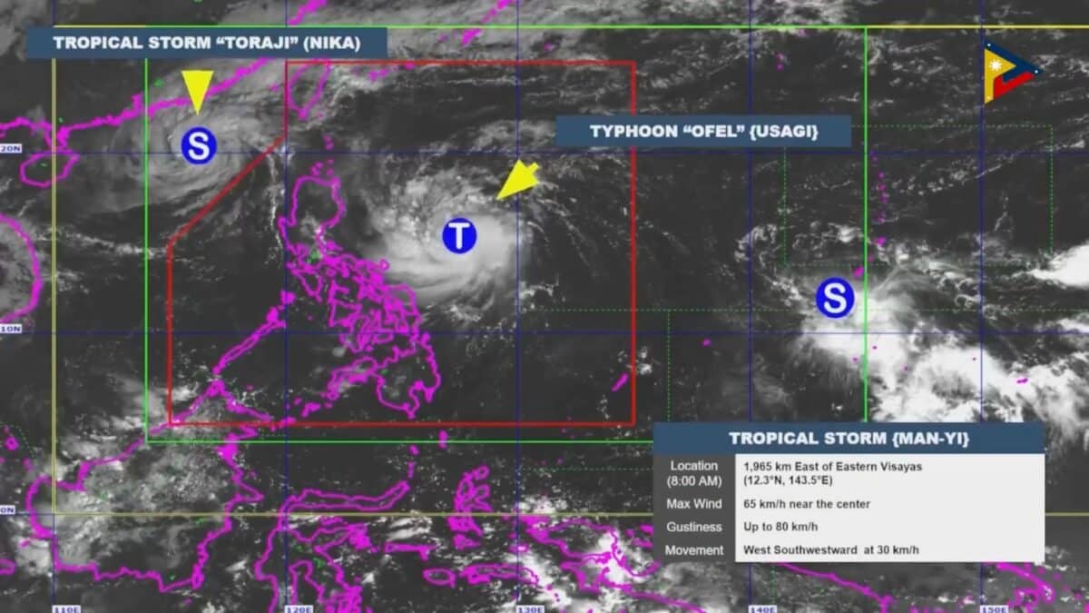

Screengrab from Civil Defense PH/Facebook
MANILA, Philippines — A specialist from the state weather bureau pointed to the ridge of a high pressure area located north of the country as a factor behind the recent string of tropical cyclones to strike Northern Luzon.
The region saw Severe Tropical Kristine (International name: Trami) make landfall in Isabela on Oct. 24, Typhoon Marce (Yinxing) in Cagayan on Nov. 7, and Typhoon Nika (Toraji) in Aurora on Nov. 11.
Article continues after this advertisementFurther, while Super Typhoon Leon (Kong-rey) made landfall in Taiwan, the cyclone brought inclement weather over Northern Luzon until it exited the Philippine area of responsibility (PAR) on Nov. 1.
FEATURED STORIES NEWSINFO Duterte threatens to slap, hit Trillanes with mic at drug war probe NEWSINFO Pagasa explains why recent typhoons tend to only hit Northern Luzon NEWSINFO New storm forecast to enter PAR Thursday to be named PepitoREAD: Typhoon Ofel keeps its strength over PH Sea; Signal No. 2 up in 2 areas
Philippine Atmospheric, Geophysical and Astronomical Services Administration (Pagasa) weather specialist Chris Perez said the tropical cyclones were mostly forced westward by the ridge of a high pressure area north of the country.
Article continues after this advertisement“Because the ridge of a high pressure area is in this northern part, the cyclones cannot move northward and instead, go westward.,” Perez said at a press briefing led by the Office of Civil Defense on Wednesday, Nov. 13.
Article continues after this advertisementTyphoon Ofel (International name: Usagi) is on track to make landfall along the eastern coast of either Isabela or Cagayan on Thursday afternoon, according to Pagasa’s 8 p.m. cyclone bulletin on Wednesday evening.
Article continues after this advertisementAdditionally, a tropical storm outside PAR with the international name Man-yi is projected to enter the country’s area of responsibility on Thursday and make landfall also in Luzon on either Saturday or Sunday.
When it enters the PAR, Man-yi will be given the local name Pepito.
Article continues after this advertisementPagasa Deputy Administrator for Research and Development Marcelino Villafuerte II remarked that the number of tropical cyclones to enter PAR this November surpassed their predictions.
“For the month of November, we forecast one to two tropical cyclones. But now, it’s almost four already. We’re waiting on Pepito. When it enters PAR, it will become our fourth for this month,” Villafuerte said.
Cyclone forecast for DecemberVillafuerte then said that the state weather bureau was expecting one or two tropical cyclones for this coming December.
Villafuerte, however, added that the onset of the northeast monsoon or “amihan” would force cyclones to move southward instead.
“Once the northeast monsoon is on the onset, if we have a northeasterly wind flow and it’s well-established, any tropical cyclones that form will move more to the south,” he said.
Subscribe to our daily newsletter
“Roughlyace666, it will be the Visayas and Mindanao areas that may be affected if there would be typhoons by December,” he added.
READ NEXT Tarlac woman nabbed for posing as niece in online love scam Duterte defies VP Sara’s appeal to excuse him from hearing EDITORS' PICK WALANG PASOK: Class suspensions for November 14 due to Ofel EDITORIAL: Smooth sailing in the West PH Sea 44 Filipinos abroad facing death penalty–DMW LIVE UPDATES: Typhoon Ofel Palace won’t stand in Duterte’s way if he yields to ICC probe Hints point to Belle Mariano singing Filipino version of ‘Moana 2’ track MOST READ PH fishers report latest Chinese ‘ramming,’ blockade at Escoda Duterte threatens to slap, hit Trillanes with mic at drug war probe Ofel nears super typhoon category; Cagayan under Signal No. 4 LIVE UPDATES: Typhoon Ofel Follow @FMangosingINQ on Twitter --> View comments